Joel Kotkin puts forward the premise that smaller urban regions are more nimble than big cities. Kotkin dubs these smaller cities like Austin, Columbus and Raleigh-Durham 'efficient cities.'
"
Joel Kotkin puts forward the premise that smaller urban regions are more nimble than big cities. Kotkin dubs these smaller cities like Austin, Columbus and Raleigh-Durham 'efficient cities.'
I’ve whipped up a bike route application using MapQuest’s bicycle routing API. MapQuest uses their directions routing algorithm and applies it to street and bike facility data available from the Open Street Map database. The generated route is available to web application developers through MapQuest’s Open Platform Web Services.
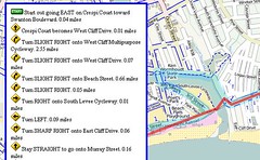
MapQuest’s Open Directions web service takes numeric latitude and longitude map coordinates as input for the start and destination of a trip. Most of us know our geographic locations as place names — something like “123 Main Street, Anytown, USA” or “Main Street and 2nd Avenue.” The process of converting these place names to numeric coordinates is called “geocoding.”
For this proof-of-concept, I’m using MapQuest’s Nominatim Search Service. Nominatim uses Open Street Map to convert place names to lat/lon combinations, but it doesn’t work for street addresses or zip codes. Only vague place names work with Nominatim, and even state names confound the search. I can get directions for Longmont to Niwot for example, but if I put “Colorado” in either place name, the place name search fails.
Two good Geocoding alternatives I know about are MapQuest Geocoding Web Service and Google Geocoding API. I’m not an experienced map application developer (this bike routing app that I wrote up over this Thanksgiving holiday is my very first one ever), so I’m interested in knowing from those with a little more experience what works well.
Here are pros and cons I see with Google’s geocode API:
MapQuest’s Geocoding service pros and cons:
I haven’t looked in detail at Yahoo’s PlaceFinder,but it seems to have a similar “You must use your map images” that Google has. Yahoo has a generous 50,000 queries per day limit, which is nice.
If you’re a somewhat experienced map web developer, what geocoding service do you recommend?
(Hat tip to Trailsnet and Recumbent Blog for letting me know about the MapQuest bicycle API. I see now that Commute By Bike also reported on this with some detail.
Related posts:

The League of American Bicyclists recently released a new book called Smart Cycling: Promoting Safety, Fun, Fitness and the Environment, and this book is a very helpful resource for anyone who is getting into cycling for the first time, or has taken some time off and needs a few refresher tips. Smart Cycling, edited by League president Andy Clarke, is an updated and professionally published version of the League’s first book, A Guide to Safe and Enjoyable Cycling, and the book covers everything from a brief history of the bicycle to basic maintenance tips.

Smart Cycling begins with the “History of Bicycling,” written by David Herlihy, who has also written Bicycle: The History and The Lost Cyclist. The book moves on to hit just about all of the topics that a cyclist would need to consider before venturing into the world of commuting or recreational riding. There is useful information on choosing a bike and the right gear, there is a discussion of rules of the road, and there are interesting pointers on handling your bicycle and avoidance maneuvers for a plethora of different riding circumstances. There are even tips on proper stretching for cyclists and basic information on fitness training.
As a guide for a beginner cyclist or for a cycling safety instructor, Smart Cycling is a comprehensive and very readable book. The information is presented in an organized progression and in language that can be easily understood by a novice cyclist (not always the case with tech manuals or safety regulations). And, for more experienced cyclists, there are plenty of insightful descriptions. After riding in traffic for years, concepts like speed positioning and signaling may seem intuitive, but reading the updated copy on best practices is a good reminder to think and act purposefully when riding a bike.
Overall, the book is well thought-out, very nicely executed, and, as an added bonus for cycling advocates, proceeds go to The League. There is a DVD with videos as well, and Smart Cycling is a great new resource for learning and teaching basic cycling benefits and safety.

Andy Clarke and his daughter discussing the new book
A while ago I was asked to help write a short piece on 'future cities', no more specific than that. The context was Australia, but fairly free. I suggested we start it with the following passage:
— Fade in —
The city of the future is established initially with north-south and east-west axial streets, and the city is laid out as a grid. Each block is envisaged as a programmable slot and is mixed-use, containing apartments, houses, shops and workshops, creating a dense city core. Between the urbanised zone and the city boundaries is a buffer zone, and beyond lies agricultural lands. Urban amenities such as plumbing, reservoirs, drainage and sewers, pedestrian sidewalks and traffic calming measures are employed throughout the city, along with public amenities like markets, public baths and toilets, theatres and religious and governmental buildings.
Socially, the city's population is actively engaged in public life, through sport, food and drink, and an outdoors '24/7' culture, but also political discussion. Active transport ensures a strong, healthy populace, almost all waste is recycled, and food production is localised and distributed throughout, orchards, vines and herb gardens integrated into living spaces. Light industrial production is also distributed throughout the city, and connected globally through trade networks. Global communications are at the centre of the city's success.
Housing is based upon the courtyard house model, with an average of 3.5 people living in a space featuring two private courtyards, one of which collects rainwater that feeds subterranean water tanks. Cooling is achieved through passive design, and heating through the inherent thermal properties of ceramics.
Although dense, 69% of land use is green space, leaving 11% for infrastructure and 20% for built area. Of that built area, fully 52% is public space and 48% is housing. Of the green space, only 2% is devoted to parks as the other 98% is a productive landscape of urban agriculture, far more ubiquitous than the hemmed-in green spaces of the 20th century city. As citizens spend much of their time in this verdant space, dedicated parks feel less necessary.
The entire urban form is modular, flexible, and capable of being repeated across numerous contexts and locales. It has been tried and tested throughout much of the known world, each time iterated and refined through adaptation.
— Fade out —
In case you didn't already guess, the mention of "public baths" might be the give-away, for this is actually a description of the archetypal Roman city circa 500 BC—500 CE (drawn from the recent book '49 Cities'). Of course, the Roman city had more than a few flaws, particularly if you were a slave. And for even the healthiest, life expectancy was far lower than we'd accept today. Similarly, there are newer technologies that we should certainly take advantage of, such as renewable energy production, wireless connectivity, bicycles and of course the espresso machine. Yet it's surprising to consider how similar visions of contemporary urban planners - with their own versions of urban agriculture, active transport, walkable densification, courtyard housing with passive design, recycling, localised production, and so on - are to this Roman city from two millennia ago.
As stated, that introduction was adapted from the entry on the Roman city from the great collection 49 Cities, a compendium of utopian city projects linked to an exhibition at the Storefront for Art & Architecture in New York City, developed by local architects Work AC.
I’ve been sitting on this review for a while, but the release of a new edition of ‘49 Cities’ has prompted me to post it. (The new edition features an introduction by Sam Jacob (FAT) and an interview with Michael Webb (Archigram), both of which should be fascinating.)
You'll know I enjoy little more than exploring possible futures of cities, so this book is a feast. It’s a lovely idea - a collection of key utopian cities, both built and un-built, compared side-by-side in terms of key criteria. This immediately throws up questions about how one judges cities - what are those key criteria? - but we’re in this game the whole time and often the discussion itself is more interesting and valuable than any sense that we might be homing in on some core, validated set of values for benchmarking cities.
So here, the measures have something of a ‘urban sustainability’ bent, albeit at a basic level, and it’s just immediately intriguing to see comparisons between, say, an archetypal Roman City or a Metabolist vision such as Helix City or Superstudio’s Continuous Monument or Haussmann’s remodelling of Paris in 1860, in terms of total built area, subdivided for industrial, housing and public, or water infrastructure, or percentages of green space given over to wilderness, agriculture, park and lawn. These comparisons are presented several ways: in detail, as tabular data and simple information graphics (usually pie-charts) for each city, and then in stacked bar chart form at the end, for assessing population density etc.
The form of the various cities is presented in lovely abstracted plans - also used as pictograms or diagrams for each city, recalling a discussion from a few years ago about how recognisable architectural forms could be - which are perhaps the most alluring thing about the book. The wonderful Metabolist visions from the late-60s look particularly wonderful. However, in comparison, the information graphics themselves are perfectly serviceable but could do with some refinement and detailing.
Inevitably, with this kind of project, there are bound to be some quibbles. As a concept, it’s almost tailor-made to generate arguments, which is no bad thing.
For instance, is Cedric Price’s Fun Palace really a utopian city project in this sense? Personally, it’s a favourite un-built building project for sure (and along with Toyo Ito’s design for the Sendai Mediatheque, the primary inspiration behind my input into the design of The Edge which opened in Brisbane recently). Yet surely it’s a building project, primarily. The line between building project and urban project is blurred, and should be increasingly so, but I find it hard to argue for its inclusion here.
Either way, if Fun Palance is ‘in’, then why not Moshe Safdie’s Habitat 67? Or Yona Friedman’s Ville Spatiale?
Or why not Cerda’s Eixample in Barcelona, or the Vinex projects in the Netherlands? This latter programme is explored in detail in the even more handsome Vinex Atlas by 010, where the fabulous level of information design by Joost Grootens indicates the quality such projects should aspire to. I have this book, and it is a truly lovely thing - but perhaps more importantly in the context of this review, Vinex Atlas thoroughly explores urban planning in reality, and how the perhaps necessarily utopian instincts underpinning it unfurl or unravel when actually applied.
And is the Roman city really utopian as such? Wasn’t it a more pragmatic, adaptive, almost iterative response to Rome’s strategic drivers than an attempt to create the ‘perfect city’? Of course, that may make it a smarter utopian model than most others in the book.
Equally, there are numerous other utopias, or imaginary cities in general, found in circuits outside of architecture and urbanism. While it would be difficult to extrapolate the quantitative comparative data from most narratives, or give a coherent idea of the form, this brings up the question of how we judge cities anyway, and which cities to compare.
These might be fantastical cities such as those found in Schuiten and Peters. Or those that hover in-between a fictional city and a real city, like Calvino's Invisible Cities (how would they score in terms of density?) In fact, this slightly absurd thought about gauging Calvino's various citta invisibli in terms of carbon footprint, population density and green space makes one consider the nature of these heavily quantitative measurements in the first place. How should we best measure a city after all?
Still, some sense of this world of imaginary cities from outside of formal architecture would have been interesting, even if many aren’t utopian as such I.e. designed as scenery or platform for dramatic structures rather than physical structures, those cities found in Metropolis or Grand Theft Auto or Playtime or Mega City One, are difficult to elide with even fantastical projections like New Babylon or Dome Over Manhattan.
Of course, most of those cities are actively dystopia rather than utopia, for dramatic purposes at least - yet using the criteria in 49 Cities would this be apparent? Mega City One would certainly score highly for density, for instance; likewise Vice City doesn't do badly for green space, as I recall. So the dystopian elements in these imaginary cities are most apparent in the socio-cultural layer, something that isn't realy explored in 49 Cities.
From the sublime to the ridiculous: a few of the New Urbanist projects such as Seaside, Celebration or Poundbury, would surely warrant discussion here? You’d hope that their inclusion would highlight the absurdity of such approaches. Then again, the high level of car dependency in those so-called walkable neighbourhoods would not become clear as it is not a criterion included in 49 Cities.
Then again, what about the countless toys, games and books that feature imaginary urban utopias for children - e.g.PlanCity - and which are surely highly formative on impressionable minds? That last point indicates why we might assess these things, after all, as utopian visions can often be used to contrast - as ‘a control’ - for the cities actually around us.
And as Sam Jacobs noted in his typically smart review for Icon, perhaps another function for the collection would be as a kind of pattern book for urban planners, maybe enabling a mashing up of utopias: Tetrahedral cities floating in Tokyo Bay, Fullerene domes at the nodes of continuous monuments, plug-in city modules embedded in Savannah squares …
The book doesn’t really address the difference between building new cities, as per Masdar, or retrofits of existing cities, as per several of the early-60s Metabolist adaptations. The latter is certainly harder to pin down, harder to draw - but is probably the way forward, most often.
The approach does yield some fascinating insights into Le Corbusier’s Ville Radieuse, which the book determines to be perhaps the most sustainable city here (along with Buckminster Fuller’s Tetrahedral City), at least using their criteria. The authors make a strong case in terms of how green - literally - the city was to be, something often overlooked due to the legions of housing projects that followed in the Radiant City’s wake. Yet Le Corbusier’s city was supposed to be “a city in the midst of vines and dense thickets with a multitude of plant life: a city in wilderness, not a city of lawns - a co-mingling of the urban and natural worlds that has intriguing possibilities again for us today.”
Certainly, brutalism works well when engulfed by foliage, and it’s fascinating to hear also of the 150 square meter “kitchen gardens” for each resident, joined to create communal gardens. These factors are rarely presented in discussions of Ville Radieuse, which has all too easily become the scapegoat for the worst in modernist urban planning.
However, the book’s selective criteria doesn’t really enable us to judge the sustainability credentials of any of these cities particularly deeply, never mind Ville Radieuse. In “putting aside (Le Corbusier’s) insistence on the separation of uses”, the authors are side-stepping key issues. Likewise the variable analysis of transit across these plans, or the social structure of the cities, or aspects of their economic base. But clearly, each of these cities would demand a book in its own right (and many have had them), if investigated to that degree. This surface view across the cities, at a glance, is still revealing and compelling.
Finally, the front of the book details a ‘fear’ timeline - indicating what the cities emerged in response to - and this highlights a particular editorial peculiarity: the long gap in entries between 1974 (Zarzis Resort) and 2006 (Masdar). This compared to one city for almost every post-war year before 1974. Has there really been a lack of interest in utopian urban visions during this thirty year period? This would be a fascinating finding, if so, and would prompt questions of architecture and urbanism active at the time. I can think of a few from this period, but I’d be interested in your submissions.
Despite the quibbles, 49 Cities is a gem of an idea, and well-realised. It prompts discussion and reflection, and most importantly perhaps, causes to look at the cities around us here and now, and critically compare them to the often inspirational visions outlined here.
49 Cities, Storefront for Art & Architecture/Work AC

And we need best practices codification with regard to promoting walking and biking (and transit) in the suburban context too.
Although I argue that the learning is pretty much the same across the board, although there are some differences. A big part is soft infrastructure -- programs that support bicycling and walking and help people make the transition. It's not enough to 'build it and they will come.' Some people will come as infrastructure is constructed, but most people will remain comfortable with their current ways of mobility, even if they aren't optimal from a number of perspectives: cost; health; environment; community.
But, how the argument has to be constructed and put forth is different, because in the suburbs especially walking and biking is seen as something you do special, for weekend recreation, and public transit (and biking for transportation) is seen as a service of last resort for poor people, generally people of color, who can't afford to buy a car--see 'Men on Bicycle' and 'In the Land of Four Wheels, Immigrants Walk in Peril' from the New York Times.
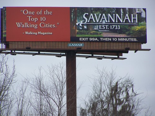
(I know that this billboard is about a city. But the majority of visitors to this city are from suburbs and part of their reason for visiting is the ability to walk in a congenial and attractive setting.)
Clean-tech incinerators are making their way into Danish neighborhoods. Why is the U.S. not implementing this technology? Environmental groups hate them, and land fills have been abundant.
 "
"
Due to complexity of the issues related to our food system, altering the food system requires the type of interdisciplinary, comprehensive thinking at which urban planners excel.
Cornell computer scientists used a supercomputer to analyze nearly 35 million Flickr photographs and determine which cities and landmarks were the most photographed. New York, London and San Francisco come out on top.
This article from Architect looks at how GIS is integrating itself into the toolbox of architects.
 Kadınlar diyetle incelmeyi hedefliyor, erkekler ise kas kitlelerini artırmak istiyor.