Saturday, November 27, 2010

Are Smaller Cities Better Equipped for the Future?

Are Smaller Cities Better Equipped for the Future?: "

Joel Kotkin puts forward the premise that smaller urban regions are more nimble than big cities. Kotkin dubs these smaller cities like Austin, Columbus and Raleigh-Durham 'efficient cities.'


read more

"

Geocode help

Geocode help: "

I’ve whipped up a bike route application using MapQuest’s bicycle routing API. MapQuest uses their directions routing algorithm and applies it to street and bike facility data available from the Open Street Map database. The generated route is available to web application developers through MapQuest’s Open Platform Web Services.


bike-directions


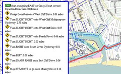
MapQuest’s Open Directions web service takes numeric latitude and longitude map coordinates as input for the start and destination of a trip. Most of us know our geographic locations as place names — something like “123 Main Street, Anytown, USA” or “Main Street and 2nd Avenue.” The process of converting these place names to numeric coordinates is called “geocoding.”


For this proof-of-concept, I’m using MapQuest’s Nominatim Search Service. Nominatim uses Open Street Map to convert place names to lat/lon combinations, but it doesn’t work for street addresses or zip codes. Only vague place names work with Nominatim, and even state names confound the search. I can get directions for Longmont to Niwot for example, but if I put “Colorado” in either place name, the place name search fails.


Two good Geocoding alternatives I know about are MapQuest Geocoding Web Service and Google Geocoding API. I’m not an experienced map application developer (this bike routing app that I wrote up over this Thanksgiving holiday is my very first one ever), so I’m interested in knowing from those with a little more experience what works well.


Here are pros and cons I see with Google’s geocode API:


  • It’s super simple to use and works well, but…
  • There’s no JSONP support. This means I’m required jump out of Javascript and write some server side PHP code to handle the geocoding response.
  • Google TOS says I must use this in conjunction with Google map images. Right now my default is showing OSM map images. That’s kind of okay with me to show Google’s map, except Google doesn’t have bicycle facility layers outside of the United States and a few Canadian cities, and even in the USA Google’s bike facility data is limited.
  • Google has a limit of 2,500 geolocation queries per day; since each route lookup involves two lookups, that’s effectively under 1300 route queries per day. This seems low to me.

MapQuest’s Geocoding service pros and cons:


  • MapQuest is migrating toward using OSM tiles for their maps, and there’s no restriction on the map tiles I’m allowed to show. I think MapQuest’s TOS is the least restrictive I’ve seen in a long time.
  • For addresses outside the United States, it appears I need to explicitly set a country code in the geocode request. This means some kind of web user geolocation, which I’d rather not get into right now.
  • MapQuest implements access control for cross domain scripting; I’ve never done this before so it’s something else I have to learn to make to make it work. (at least, I think that’s the problem I’m having, though I could be wrong).

I haven’t looked in detail at Yahoo’s PlaceFinder,but it seems to have a similar “You must use your map images” that Google has. Yahoo has a generous 50,000 queries per day limit, which is nice.


If you’re a somewhat experienced map web developer, what geocoding service do you recommend?


(Hat tip to Trailsnet and Recumbent Blog for letting me know about the MapQuest bicycle API. I see now that Commute By Bike also reported on this with some detail.


Related posts:

  1. Bike directions Toronto, Ontario

  2. Google Maps "Bike There" directions

  3. Google Maps bicycle directions pro tips


"

Smart Cycling: A Review

Smart Cycling: A Review: "

The League of American Bicyclists recently released a new book called Smart Cycling: Promoting Safety, Fun, Fitness and the Environment, and this book is a very helpful resource for anyone who is getting into cycling for the first time, or has taken some time off and needs a few refresher tips.  Smart Cycling, edited by League president Andy Clarke, is an updated and professionally published version of the League’s first book, A Guide to Safe and Enjoyable Cycling, and the book covers everything from a brief history of the bicycle to basic maintenance tips.


Smart Cycling begins with the “History of Bicycling,” written by David Herlihy, who has also written Bicycle: The History and The Lost Cyclist.  The book moves on to hit just about all of the topics that a cyclist would need to consider before venturing into the world of commuting or recreational riding.  There is useful information on choosing a bike and the right gear, there is a discussion of rules of the road, and there are interesting pointers on handling your bicycle and avoidance maneuvers for a plethora of different riding circumstances.  There are even tips on proper stretching for cyclists and basic information on fitness training.


As a guide for a beginner cyclist or for a cycling safety instructor, Smart Cycling is a comprehensive and very readable book.  The information is presented in an organized progression and in language that can be easily understood by a novice cyclist (not always the case with tech manuals or safety regulations).  And, for more experienced cyclists, there are plenty of insightful descriptions.  After riding in traffic for years, concepts like speed positioning and signaling may seem intuitive, but reading the updated copy on best practices is a good reminder to think and act purposefully when riding a bike.


Overall, the book is well thought-out, very nicely executed, and, as an added bonus for cycling advocates, proceeds go to The League.  There is a DVD with videos as well, and Smart Cycling is a great new resource for learning and teaching basic cycling benefits and safety.


Andy Clarke and his daughter discussing the new book


"

Urban and suburban and rural attitudes and voting

Urban and suburban and rural attitudes and voting: "I wouldn't normally blog about an article like this 'Drubbed in statewide races, Maryland GOP may drop top-down approach to party growth,' from today's Post, about the state of the Republican party in Maryland and its opportunities in a seemingly very Democratic state, except for what it says about rural vs. urban attitudes. From the article:

Despite getting shellacked in statewide contests, Maryland Republicans actually made significant gains Nov. 2 in races for county commissioner and council seats, expecially in less-populous parts of the state.

Building on those pickups - and in turn building a farm team for bigger races down the road - might be the most realistic strategy at this point, some argue.


While the article acknowledges that the Republican gains in Maryland were mostly in 'less populous' areas, it doesn't discuss how important this point really is, especially in terms of where most of the votes and most of the Maryland population is located--adjacent to Washington DC and in and around Baltimore. Suburbanites in those areas may be less liberal than people in the 'center city,' but at the same time they are likely to be considerably more liberal than residents of exurban and rural areas.

2010 Election results by county, Maryland Governor, Washington Post graphic, modified to include Baltimore County
Early election results by county, Maryland Governor's race, modified to include Baltimore County, Washington Post graphic Blue = Democrat, Red = Republican. In 2006, the state population was 5.7 million and the jurisdictions that voted Democrat made up 63% of the state's population. In the next two largest counties, Anne Arundel and Frederick, the Republican slate for Governor won with about 54% of the vote, but as these counties continue to be drawn into their respective center city orbits, the trend away from Republican voting is likely to continue.

So the Republican victories in Maryland (with the exception of the Congressional results in the 1st District) are growing in the least populated, slowest growing areas of Maryland. How is that a good thing for the Republican party and what does it say as the country continues to suburbanize?

Plus, the article doesn't get into how the Republican party appears to be decidedly anti-urban in terms of its policies, at least nationally, (it is true that enlightened Republicans at least in terms of the smart growth issue do actually exist, e.g., Mitt Romney is actually quite good on Smart growth issues and did a lot of good things as governor of Massachusetts--sadly, these policies were seen as 'Republican' not merely smart, and rejected by his Democratic successor).

See:

-- Conservatives' Vision of an America without Cities
-- A line in the suburban sand
"

Saturday, April 17, 2010

How to Travel With Your Bike

How to Travel With Your Bike: "Reach your destination quickly, easily, and safely with these ten bike travel tips."

Perpa'nın bahçesi imara açıldı ama...

Perpa'nın bahçesi imara açıldı ama...: "Perpa'nın ön ve arka bahçeleri mülk sahiplerinden habersiz imara açıldı, ihaleye bile çıkıldı. Mülk sahipleri haberdar edilmedi çünkü artık bu alanlarda hak sahibi olmadıklarını öğrendiler."

İstanbul'da yapmanız gereken 101 şey

İstanbul'da yapmanız gereken 101 şey: "Gün batarken Kız Kulesi'nin en güzel göründüğü Salacak sahilinde, ince belli cam bardakta sıcak bir çay yudumlamak, vapurun ardında sıralanan martılara simit atmak, Kanlıca Körfezi'ne bakan Mihrabat Korusu'nda mehtabı izlemek, mayıs ayında boğazda yapılan bir tekne gezintisi ile baharın habercisi erguvanları seyretmek, öğle vakti Sultanahmet ve Firuzağa camileri arasında müezzinlerin birbirlerinin nağmelerini kesmeden okudukları çifte ezanı dinlemek..."